There are numerous trails and walking paths in and around Branson, covering a wide range of topographies and having varying lengths and surfaces. The City of Branson’s Parks & Recreation Department has fantastic trails and walking paths right here in the city limits, so you won’t have to go very far from your hotel to find great walking and hiking possibilities.
Bluff, Bent Tree, and Ridgetop Loop
After travelling 0.6 miles west on W Main Street from the centre of Branson, turn right onto W 76 Country Boulevard. Turn left onto Fall Creek Road/Yellow Route after travelling 0.8 miles. Immediately turn left, and then quickly turn right to enter the parking lot for this trek. Stunning in every way are the Bluff, Bent Tree, and Ridgetop Loops. This expedition, which is arguably Missouri’s most picturesque path, showcases a variety of the state’s natural characteristics over a brief but difficult journey.
As you travel across the spectacular scenery, stroll beneath the chiselled cliffs through the deep Missouri woods. You will face a difficult struggle in order to reach the gorgeous ridge. While the high-rooted terrain is manageable, the near entirety of the elevation gain is completed as a long set of carefully carved stone steps.
A seemingly never-ending journey through the lovely woodlands involves 240 stairs in all. The return loop is fortunately only 98 steps long, which will be good for your knees. You’ll be rewarded with genuinely amazing vistas of Missouri’s most impressive features once you’ve conquered the infinite staircase. You can enter several little caverns along the ridge that are hidden beneath the enormous granite cliffs. At the summit of the loop, you will also be rewarded with a sweeping vista of the magnificent Lake Taneycomo and its gently rising valley.
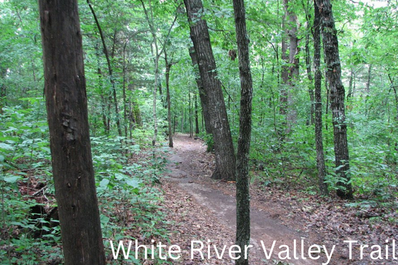
White River Trail System
After travelling 0.3 miles west on W Main Street from the centre of Branson, turn onto US-65 S heading toward Harrison. After travelling 6.0 miles, make a right turn onto State Highway 265 North. Turn right to remain on State Highway 265 N after travelling 0.7 miles. Turn left to continue on State Highway 265 N/Historic Highway 165 N after travelling for an additional 2.5 miles. Turn right after 2.2 miles, and the parking lot will be on your left.
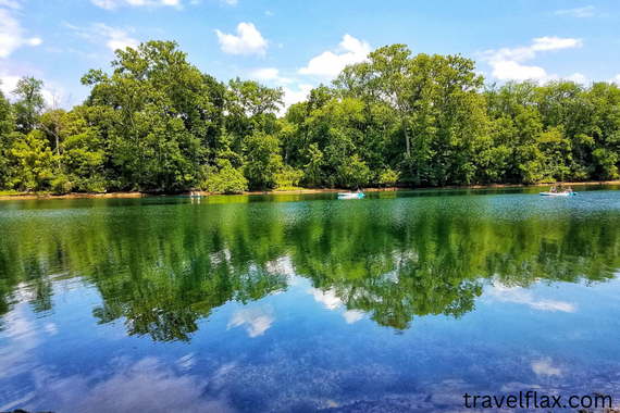
The White River Trail System is a challenging hike along a variety of hiking trails. The journey becomes a comprehensive representation of Missouri’s natural landscape by merging the Red, Blue, Orange, and Green Loops. The walk meanders through verdant forests with low-hanging vegetation that offers pleasant, breezy shade. These routes are a seasoned mountain biker’s dream because to the well-maintained conditions and the wide pathway.
Even though there is elevation increase, most of the climbs are consistently doable ascents on safe hiking terrain. As you across amusing brook crossings, the hike will lead you to the banks of various slow-moving creeks. Along the way, you’ll come across old roads, a farmhouse that’s long since been abandoned, quiet little waterfalls, and a wide variety of different kinds of trees. Wide-ranging views of charming Table Rock Lake can be seen from the tallest overlooks.
Roark Creek Waterfall Trail
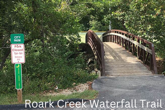
Drive 0.6 miles west on W Main Street starting in the centre of Branson. The parking lot for this trek is on your left after turning right onto Blue Route/Roark Valley Road and travelling 2.1 miles. The Roark Creek Waterfall Trail is a hidden gem in Branson. Through a thick, lush overhanging forest, this unusual journey follows the Roark Creek creek bed.
Numerous eye-catching elements, such as cascading waterfalls and astounding geological mountain cliffs, will be present as you go through the woodlands. The Roark Creek Waterfall, which bears the hike’s name, is where it all begins. The waterfall is quite wide but not particularly tall. A serene pool is formed beneath the tranquil falling waters as the creek gently cascades from the bluff’s top. From here, you may take a stroll up to the top of the falls and take in a lovely picnic from the cliffside of Branson’s busiest shore.
Homestead Trail
Numerous eye-catching elements, such as cascading waterfalls and astounding geological mountain cliffs, will be present as you go through the woodlands. The Roark Creek Waterfall, which bears the hike’s name, is where it all begins. The waterfall is quite wide but not particularly tall. A serene pool is formed beneath the tranquil falling waters as the creek gently cascades from the bluff’s top. From here, you may take a stroll up to the top of the falls and take in a lovely picnic from the cliff-side of Branson’s busiest shore.
There are 15 markers in all along this informative walk. Each marker recounts a tale of the early settlers in the last of Missouri during the gold rush. The trail will then turn off into an unusual wetland, where there are many different types of wildflowers, reptiles, and birds. The region is a perfect environment for insects that reproduce indefinitely due to the quantity of resources.
Table Rock Lakeshore Trail
After travelling 0.3 miles west on W Main Street from the centre of Branson, turn onto US-65 S heading toward Harrison. After travelling 6.0 miles, make a right turn onto State Highway 265 North. Turn right to remain on State Highway 265 N after travelling 0.7 miles. Turn left to continue on State Highway 265 N/Historic Highway 165 N after travelling for an additional 2.5 miles. Turn right after 2.2 miles, and the parking lot will be on your left.
A lovely hike through Table Rock State Park is the Lakeshore Trail at Table Rock. The walk begins on the magnificent shoreline of Table Rock Lake, a tranquil lake with geologically distinctive sandstone bluffs serving as your backdrop. Numerous endangered species, such as bald eagles and fiery foxes, can be found in good numbers around the lake. The path divides and leads into the park’s luxuriant trees. Except for a couple of wooden bridges, the entire trail is paved. This trip is appropriate for hikers of every level due to the level terrain and smooth pavement. When you’re done, don’t forget to plunge into Table Rock Lake’s chilly waters to unwind and recharge in the vitality of this renowned park.